
Tourism Destinatons
About Blitar Regency
Blitar
is the second small regency in East Java province.
Blitar is noteworthy for being the hometown
of Indonesia's first president, Soekarno. It's
a sleepy place that's got a tiny business district
as well as ancient Hindu temples (called Penataran
temple).
Blitar city has a principle that is “Kridho
Hangudi Jaya” (work hard to reach the
glorious) and its motto “Blitar Kota Patria”
(Blitar the defender of the nation that well-regulated,
cleanly, beautiful, and safety), also known
as heroic city, student city and peaceful city.
Blitar city has try to build its city as ‘Patria’
city which supported by it commerce system.
Blitar government chooses the tourism sector
as the main product to increase its economic
region.
GEOGRAPHICALLY
Blitar Regency is one of the second level regencies
that located between 112° 14 - 112°
28' East Longitude and 8° 2 -8° 10 South
latitude covering 1,588,79 km2. Blitar boundaries
are:
North side: Kediri and Malang regency
South side: Indonesian Ocean
East side: Malang regency
West side: Tulungagung and Kediri regency
CLIMATOLOGY
The highest temperature in Blitar is 30°
and the lowest temperature is 18° c. The
rainfall rate per year is 31.6 - 4000.846 m2.
WIDE AREA
The wide land area is 32.578 km2. It is separated
by Brantas River that flowing from east to west.
North side: 848.79 km, fertile land with declivity
0 - 2%. Kinds of land are regosol, litosol,
and main material volcanic of quartz sand smooth
texture and little rough texture.
South side: 690 km, kinds of land are litosol,
mediteran and rezone is on the declivity 5 -
40%.
Kinds of land area are:
- Field 30.74%
- Forest 21.56%
- Houses 16.96%
- Plantation 8.48%
- Water 0.05%
- Others 0.66%
TOPOGRAPHY
The Brantas River flowing from the East to the
West divides Blitar regency into 2 separated
regions. In North Blitar regions has a very
fertile land type with the land declivity 0
- 2%. The Sorts of land consists of regosol
and litosol with the main material of quartz
sand covering 898.79 km2. The Width of North
Blitar region is 690 km and its topographic
land condition has the declivity 2 - 2 % with
the sorts of land consist of litosol, mediteran
and rezone which are the main material lime
stone in mediocre texture with the effective
depth about 30 - 60%.
GEOLOGY
The utilities of land in Blitar regency are:
- Technical irrigation rice field: 19,102,753
Ha
- Semi technical irrigation rice field: 5,171,367
Ha
- Non-technical irrigation rice field: 6,327,729
Ha
- Rainy dependence rice field: 1,133,700 Ha
Land structure condition:
- Rice field: 32,962,589 hectares
- Dry rice field: 48,047,258 hectares
- Pond / Embankment: 136,040 hectares
- Housing: 27,761,934 hectares
- Plantation: 13,279,303 hectares
- People's forest: 3,474,759 hectares
- State forest: 23,737,200 hectares
- Uncultivated land: 250,000 hectares
- Miscellaneous: 8,630,081 hectares
ADMINISTRATION
Blitar regency is divided into 3 sub districts,
and 20 districts, they are; Bakung district,
Binangun district, Doko district, Garum district,
Kademangan district, Kanigoro district, Kesamben
district, Ngeglok district, Panggungrejo district,
Ponggok district, Sanankulon district, Selorejo
district, Srengat district, Sutojayan district,
Talun district, Udanawu district, Wates district,
Wlingi district, Wonodadi district, Wonotirto
district, Gandusari district, Selopuro district.
DEMOGRAPHY
The population registration in 2005 shows that
the population in East Java is increases from
the mid 2005 to the mid 2006.
The total population of Blitar regency is 123.194
with number of men 526,390 and number of women
535,257 while, total of workforce 462,265.
The activities in socializing orderliness, cleanliness,
working spirit have been successfully carried
out in Blitar, has received awards in the orderliness
of roads and traffic called “Piala Wahana
Tata Nugraha”, a high appreciation from
the President of the Republic of Indonesia.
Besides, other activity in maintaining the awards
in city’s cleanliness and orderliness
called Adipura awards also has been achieved.

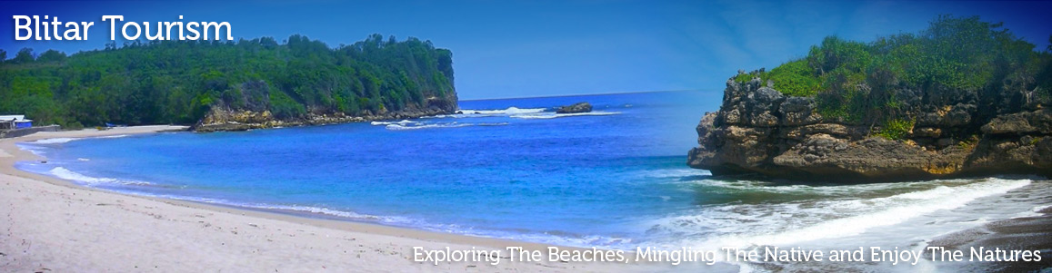
The Blue Adorable Sky On Serang Beach
Serang Beach Serang beach is located in Serang village, Panggungrejo sub-district, it ‘s about 40 Km from Blitar city. This beach is stunningly beautiful. The sea water has turquoise color and strong waves, typical of Indonesian south sea. Moreover, the greenish nuance is also can be found around the hill in the next side of the beach. The visitors who come to the beach can hike the cliff and fishing. In fact, there are numbers of fisherman who traditionally fishing the lobster and fishes. More info visit: www.eastjava.com
Here Go Tambakrejo
Tambakrejo Beach is located about 30 km from Blitar city, in Tambakrejo village, Wonotirto district. In this location, in every first Suro month (the new year in Java calendar) is performed a “Larung Sesaji” ceremony, and visited by thousands people from various areas. The south sea (Indonesia Ocean) waves splashing and the sunshine in the evening, make the situation feel peaceful. It is compatible for the townsman who had bored with the metropolitan life. They can enjoy the natural beach with its beautiful waves and beautiful sunset. The visitor can…
Karangsari Tourism Products
Karangsari Agro Tourism Karangsari Village, Regency of Sukorejo, Blitar is become popular because of the Star Fruit (Belimbing). What makes this star fruit become so famous is coming from the size, which has jumbo size, and it has sweeter taste than commonly star fruit, with tempting light yellow. While doing devotional visit to Bung Karno graveyard, you can spend your time visiting Karangsari village and buy the star fruit as a gift. While enjoying the atmosphere at Karangsari village you can also see the star fruit’s tree over the road,…
Tambakrejo Beach
Tambakrejo Beach Tambakrejo Beach is located about 30 km from Blitar city, in Tambakrejo village, Wonotirto district. In this location, in every first Suro month (the new year in Java calendar) is performed a “Larung Sesaji” ceremony, and visited by thousands people from various areas. The south sea (Indonesia Ocean) waves splashing and the sunshine in the evening, make the situation feel peaceful. It is compatible for the townsman who had bored with the metropolitan life. They can enjoy the natural beach with its beautiful waves and beautiful sunset. The…